Tropical instability waves (TIWs) are instabilities in the shear zone between the South Equatorial Current and the Equatorial Undercurrent.
TIWs are generally strongest between 1-7N. They usually form around 100-110W on the strong meridional temperature and velocity gradients there and then propagate westwards, with increasing north-south excursions where the background temperature gradients are weaker.
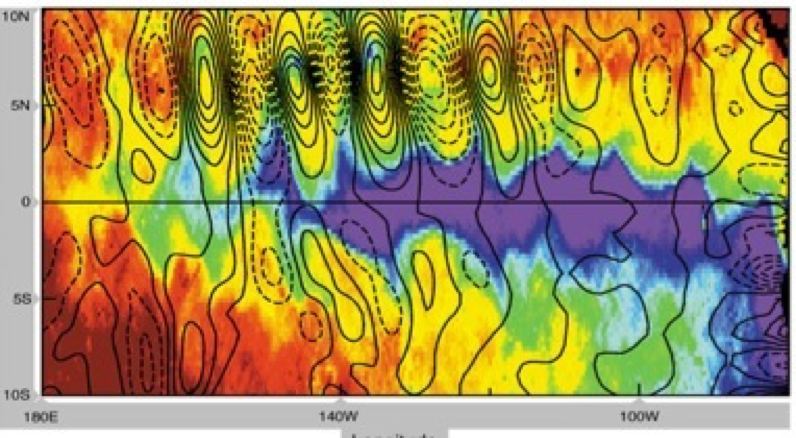
Figure | TIWs
These instabilities have zonal wavelengths of 800-2000km but are very narrow on the cusp of the wave, and hence are often not resolved or poorly resolved in climate models (see Harle et al, 2008; Roberts et al, 2008 for further details). They act to move cold water away from the equatorial cold tongue and mix warm water onto the equator (both at the surface and sub-surface) and are modulated seasonally and inter-annually, being weakest during boreal spring and El Nino events. They are important both for the mean state and variability of the ocean in the tropical Pacific, and also significantly influence the atmospheric circulation, particularly the Walker circulation. They are also likely to be sensitive to the dissipation parameters, especially when they are only marginally resolved.
The TIWs in our low-resolution model (LoLo) are rather weak, and their main activity is displaced further to the west than is observed. In the high-resolution model (HiHi) the TIWs have a more realistic variability and occur only slightly westward of the observations. The meridional flux of heat in the ocean due to the TIWs is much stronger in HiHi than LoLo (unfortunately too few observations exist to validate this) and this leads to a great improvement in the ocean temperatures, both at the surface and at around 130W at 100m on the equator in HiHi. The consequent improvement in the slope of the thermocline along the equatorial Pacific (the zone of strong vertical temperature gradient) may be very important for wave processes linked to El Nino/Southern Oscillation. The improved sea surface temperatures allow the HiHi model to simulate a much more realistic atmospheric circulation in the tropical Pacific, with improved winds and precipitation.
Experiments were also conducted in which the horizontal ocean momentum dissipation was varied in both LoLo and HiHi. It was found that the LoLo model simulation could be improved with using a lower value for the ocean momentum dissipation, though the model tends to become numerically unstable at the lowest values. In the HiHi model, increasing the momentum dissipation makes the simulation look more like the LoLo model.